Oct 142014
 

“Escape the pressure of the city for a life at the Lake!” proclaims this late 1940s or early 1950s real estate brochure. 

733732

(click to enlarge)

Interior copy promises a private domain to armchair shoppers reading and dreaming from their harried homes in the big city.

See the Splendor of SHAWNEE BEND or HORSESHOE BEND

The magnificent 4500 acres of Shawnee Bend and the picturesque 5500 acre Horseshoe Bend are the finest acreage at the Lake of the Ozarks. The green hills are thick with oak, cedar and dogwood. Much of the land slopes gently to the shores of the lake … requiring little clearance and offering wonderful beaches. All sites have ample lake frontage with plenty of room for your own individual beach and dock space. This lake frontage belongs to the owner of the land. State approved water systems, electric power, and fine all-weather roads offer you all the conveniences of the city.

Promises made back then are still controversial today. Recently Ameren and Lake homeowners disagreed on who owns the land to the water’s edge.

The buy of the century! Does anyone know what happened to the business? It was not a fly-by-night outfit and continued well after Cyrus Willmore’s death in 1949. (more info on Cyrus Willmore and the lodge on page 127 of Damming the Osage)

We have a link to Willmore Lodge in our Resources menu.


Aug 132014
 

Aerial photo of Old Linn Creek before being flooded by Lake of the Ozarks(click to enlarge)

8 x 10 press photo captioned “Move Entire Town to Make Room for World’s Largest Artificial Lake”
(photo credit: ACME)

This press photo dated March 26, 1931 shows what remained of the soon-to-be-covered-with-forty-feet-of-water town of Linn Creek, once the seat of Camden County, Missouri. Many structures had been torn down in this town that was once home to 500+ residents. Some  buildings were moved to the new Linn Creek a few miles away on higher ground. A new county seat was built – Camdenton, Missouri.

There is quite a literature about towns drowned by reservoirs. You can Google “drowned towns” or follow the links below:

http://librarybooklists.org/mybooklists/drownedtowns.htm

Or – for a world view:

http://weburbanist.com/2014/03/10/drowned-towns-10-underwater-ghost-cities-buildings/

The movie Deliverance, based on the novel by James Dickey, is of course about a river about to be impounded. Near the end of the movie there are shots of a church being moved out of the basin.

But back to old Linn Creek – Our assumption was that what they didn’t tear down or move, they burned. Considerable expense was incurred clearing the trees out of the basin for Lake of the Ozarks, but as this photo shows, they didn’t get them all. Timber removal was a surprising percentage of the cost of the whole project. There was some tension between the crews hired to clear the timber and anti-dam residents when the crews ate at the restaurants and used the stores and filling stations of the town.  People in Linn Creek were pretty much against the dam – a sentiment led by J. W. Vincent, editor of the Linn Creek Reveille.

There are a lot of aerial photos of the dam under construction and as the lake filled – but not so many of the demise of Linn Creek.


Aug 112014
 
Surveyor's Plat of Rocky Comfort at Lake of the Ozarks, 1937

Surveyor’s Plat of Rocky Comfort at Lake of the Ozarks, 1937

We can surmise that this is a surveyor’s map of a subdivision of seventy-four lots laid out by then-owners H. O. (Orville) and Ruth Gatlin, notarized on July 6, 1937 by “George Clifford Williams, Notary Public in and for Morgan County.” This mimeographed map handout shows residential lots apparently being offered for sale along the lake shoreline. The Gatlins were pioneer developers to an area as yet largely undeveloped for recreation and tourism, especially along the upper stretches, away from “The Strip” at Bagnell Dam and Osage Beach.

(click to enlarge)

In the early days of the Lake, Union Electric was more concerned with power production than with real estate sales. Truthfully, the sale of shoreline property and vacation homes wasn’t much of a business during the Depression and World War II. It’s possible that some of the current conflict over the intrusion of private shoreline lots into Union Electric property goes back to the early days of the utility company’s sales of shoreline properties. We don’t see on this map any indication that there is between the privately owned lots and the lake a zone that belonged to Union Electric by law. We wonder if this was disclosed to the buyers of these lots back in those days.  It is now alleged that owners have encroached on power company land.  For more info, see Donald Bradley’s article in the Kansas City Star (May 24, 2014), Lake of the Ozarks residents take land dispute to court.

The federal government saw the real estate arm of Union Electric as a  conflict of interest and the company was required to divest itself of large blocks of land around the lake. We’ve recently acquired an early printed brochure of the Willmore Company which “won the 1945 auction of Union Electric’s 42,000 acres ordered by the Securities and Exchange Commission.” Willmore later tried to sell 4,000 of those acres to a local businessman for $10,000, but Buford Foster couldn’t swing the deal. (Page 138, Damming the Osage).  Those acres included virtually the entire Shawnee Bend area with miles of shoreline.

According to Lake historian H. Dwight Weaver, the Gatlins moved to the Gravois Arm of the Lake the same year that the subdivision was platted (1937), purchasing 110 acres where they built Rocky Comfort Lodge. The large rock and frame lodge served guests until it burned in 1942. Rather than rebuild the lodge, the Gatlin’s turned their attention to their boat yard. The boat yard continued through several owners and today is Kelly’s Port Marina. Weaver’s book, History and Geography of Lake of the Ozarks, Vol. Two, provides a two-page account of the Gatlin’s businesses at Rocky Comfort and subsequent ownership of the property.

Mr. Weaver’s books are available through his website: Lake of the Ozarks Books – http://www.lakeoftheozarksbooks.com/

May 082014
 

Pollution at Lake of the Ozarks, complicated by denial and cover-ups

Naturally environmentalists are more concerned about the degradation of rivers, especially if they cut through uninhabited, scenic country, than a reservoir whose shores are lined with condos and whose waters are whipped to a froth by cabin cruisers. THE SCARS OF PROJECT 459, journalist Traci Angel’s lively account of water quality problems at Lake of the Ozarks, reports that when concerned citizen Barbara Fredholm contacted the Sierra Club to start a local chapter she was told, “the Lake of the Ozarks is a lost cause.”

459-bookThe Lake’s 55,000 acres of murky Osage River water is held back by Bagnell Dam, which was closed in 1931.  Ostensibly, Project 459 was to supply hydropower to lead mines in eastern Missouri, which were in a downward spiral of operation like all American industries at the beginning of the Depression.  The financing and justifications of Lake of the Ozarks were scandalous.  Two out of three of the drivers of the scheme ended up doing time in federal penitentiaries. The Lake’s origin smells like Polanski’s Chinatown, but without the murders and incest

Today, certain coves at Lake of the Ozarks stink from time to time, polluted by inadequately treated human and animal waste. The politics of dealing with the problem are complex, but driven more from old-fashioned self-interest than out and out corruption.  Still, this book reveals a pattern of inadequate response to a real problem.

It is understandable that the Sierra Club would have a minimal interest in an aging impoundment owned by a power company that is overbuilt and under-regulated, but the book finds the behavior of some politicians and government agencies unforgivable. In 2009 the Missouri Department of Natural Resources delayed releasing until after Memorial Day a report that had found dangerous levels of E. coli bacteria in popular swimming coves, fearing the tourist season would be harmed. The press ran with this story and it became a scandal. Heads rolled in Jefferson City.

Unfortunately, the lesson learned, Angel found, was that now our political and regulatory agencies run and hide when queried about water quality problems.  When she sought an interview with the Missouri Department of Natural Resources, she was told in an email: “We understand that the University of Arkansas Press has contracted with you to write this book, which will be sold for a profit. Given that we are a public agency supported by tax dollars, we have determined that it is not an appropriate use of limited staff time to participate in these types of interviews.”  The implication of such a policy pretty much shuts down the publication of books, newspapers, radio, television and magazines, as they are all “sold for a profit.”  Further, such a policy would shield from public scrutiny information derived from publicly funded research

When she tried to get information from Governor Jay Nixon she was told to check in with the Department of Natural Resources and “insofar as making the Department available for interviews, I believe the Department of Natural Resources is in the best position to make the call on that and I won’t be compelling them otherwise.”

So who will tell the truth about the environmental problems of a geriatric reservoir?  Actually, the author found a scattering of local residents, business people and a few politicians and bureaucrats who do approach the problem straightforwardly.  Apparently Angel herself is part of the American tradition of muckraking journalists – and there’s some smelly muck to rake down there in Lake of the Ozarks.

Modified landscapes, like dammed rivers, are still environments that can be further neglected and abused. Traci Angel does, by the way, point out some outstanding natural features like the spectacular Ha-Ha-Tonka State Park which is intelligently managed by a division of the Missouri Department of Natural Resources which dropped the ball on the pollution issue.

Lake of the Ozarks isn’t a lost cause but its heritage of lies and hype continue to plague its management.

The book is available at www.amazon.com

Jan 282014


02-v2Before Truman’s dam waters rose, there was promise of new entrepreneurial opportunities to be had with the coming of a mammoth lake. We found these roadside offerings during paddlefish snagging season in the mid 1970s.

Since the dam closed, we have been amazed at the scarcity of tourist related imagery for Truman Dam and reservoir compared to the wealth of tchotchkes for Bagnell Dam and Lake of the Ozarks. There are hundreds of times more decals, spoon holders, compacts, plates, salt-and-pepper-shakers, tablecloths, pocket knives, matchbooks, postcards, brochures, etc. for the 1931 project

539To some extent this can be explained by the fact that we are, alas, no longer in the era of the souvenir spoon. It’s a well known fact that contemporary Americans are far more refined and sophisticated than their kitsch collecting grandparents – Right?

The sad truth is that Truman Dam and Lake have failed to develop into the promised and anticipated tourist mecca.  Even the dam itself is architecturally bland compared to the structure that creates Lake of the Ozarks. It lacks a singular identity, an iconic image, which are important components of success in the tourism industry.

We were sure at the time of the lawsuit, that the environmental damages would be unavoidable. Predictions of economic benefits to the area from tourism we suspected were exaggerated. As things have turned out,  the promised profitable tourist industry has been a disappointment (putting it mildly). A recent PhD thesis – “The Changing Landscape of a Rural Region: The Effect of the Harry S. Truman Dam and Reservoir in the Osage River basin of Missouri ” – by Melvin R. Johnson bears out our pessimistic appraisal and personal observations as we travel the area.

Continue reading »

Jan 152014
 

453Cast aluminum and painted license plate frame, circa 1940s

Lake of the Ozarks filled in 1931 but the Depression and World War II stymied its tourism development. From the late 1940s on, gift shops located along Highway 54 offered hundreds of kinds of objects to verify that you had indeed visited beautiful Lake of the Ozarks.  As the lake itself is all but unphotographable — like all reservoirs in existence, a parking lot for water — the favored icon was Bagnell Dam, which it must be conceded, is quite graphic.

By contrast, Truman Dam has all the charm of a gigantic farm pond, with a little center section of brutal concrete – boxy and utilitarian, impersonal, boring. Interestingly, we haven’t found anything like the number or variety of physical souvenirs of Truman to compare with the almost endless numbers of Bagnell Dam vacation memorabilia.

474 Continue reading »

Jan 082014
 

731

Advertising Brochure, 1940s

We devoted a full page (p. 129 to be precise) to the Gov. McClurg in Damming the Osage but we just acquired this ephemeral treasure – a brochure advertising the dining, dancing and photography opportunities available to visitors on their lake cruises. The Sunset Cruise was at 7 p.m.; Nature’s own romance trips, the Moonlight Cruise was at 9; and on the 11 p.m. cruise, vacationers could dance their way into the wee hours to “an excellent selection of music.” Local bands often supplied the music. During the summer of 1955, the Bob Falkenhainer Quartet supplied the rhythms; one of the quartet was Marshall, Missouri high school student,  Bob James, now famed jazz keyboardist, producer and arranger. It was an ideal gig for a teenager – play the summer evenings away and swim and water ski through the days.

Before the lake filled, Highway 5 crossed the Osage River at the toll suspension bridge near Linn Creek. While two modern bridges were being built to connect Versailles with Camdenton, the custom built Gov. McClurg ferried cars across the river. It carried twenty cars at a time the mile and a quarter from Lover’s Leap to Green Bay Terraces, an early Lake development. Backed up traffic was common on weekends.

When the new bridges were finished and Highway 5 relocated, the Governor McClurg ferry was refurbished as an excursion boat.  Through the late 1930s and into the 1960s, the Gov. McClurg showboat offered day or night lake cruises from its dock at the west end of the Glaize bridge.

When the Lodge of the Four Seasons acquired the Gov. McClurg excursion boat, it was renamed the Seasons Queen.

The boat was named for Joseph W. McClurg, respected citizen of old Linn Creek.  He was a well educated, dapper gentleman, who, before the Civil War, was co-owner of the Linn Creek Big Store which did a half million dollars a year business. After the Civil War McClurg was elected to Congress three times and governor of Missouri once (1868). “The soft spoken, religious, teetotalling McClurg could be considered the most distinguished figure in early Osage valley history. Certainly, he was the only personage in the region photographed by Mathew Brady.” (page 54, Damming the Osage)

Continue reading »

Dec 152013
 

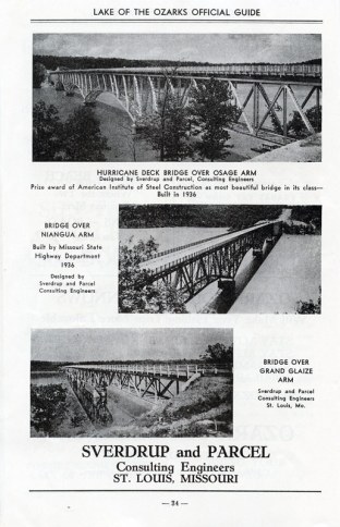
The last of three bridges designed by Svedrup and Parcel dynamited and replaced by new span.

December 8, 2014 – Missouri’s highways and transportation commissioner pushed the plunger, detonating dynamite on a 740 foot section of the Hurricane Deck bridge that once carried Highway 5 over the Osage River arm of Lake of the Ozarks.  According to the bridgehunter.com website, the 1936 bridge was ‘structurally deficient’ and clearly the highway department agreed. The steel will be pulled out of the lake and the rest of the bridge will be taken down in additional demolitions in coming weeks.

Video from Springfield TV station, KOLR-10, shows the demolition blasts and collapse of the first spans to be dropped into the lake.

Early in the development of the Lake, Sverdrup and Parcel, a St. Louis firm, was engaged to design and construct bridges to connect communities in Morgan and Camden counties that were now cut off from each other.  When Damming the Osage was published (2012), the 1936 Hurricane Deck bridge – which was named the most beautiful bridge in its class that year by the American Institute of Steel Construction – was the last remaining span over the lake by that firm. Additional information is available at Bridgehunter.com  http://bridgehunter.com/mo/camden/hurricane-deck/

399Leif Sverdrup, a Norwegian immigrant, with his college engineering teacher, John Parcel, founded the company in 1928. During World War II, General Sverdrup became chief engineer for General Douglas MacArthur.

IMG_7520

Among many distinctive spans, the firm also designed the graceful twin bridges that cross the Missouri River at Jefferson City.

Sverdrup and Parcel also designed the pair of steel-through-arch bridges crossing the Missouri River at Jefferson City  (Cole County, Missouri) in  1955. These spans still carry traffic on the multi-lane freeway of US 54/63.

(click on image to enlarge)

Dec 102013
 

725

Real Photo Postcard, circa 1930

Ha Ha Tonka is a cornucopia of karst features – springs, caves, cliffs, sinkholes and a natural bridge., was described in a 1940s brochure: “the 600-acre tract includes all the natural wonders of the place, among which are a 90-acre lake, with a wooded island; a spring producing 158,000,000 gallons of water daily; a natural bridge; seven caves, one of which has been explored for a distance of about two miles and which contains the largest known stalagmite; a natural amphitheater; and many curious and fantastic formations, such as the Balanced Rock and Devil’s Kitchen.”

Now a very popular Missouri State Park, Ha Ha Tonka was originally the property of the Snyder family in Kansas City.  Robert Snyder Sr. built a stunning ‘castle’ there on a bluff overlooking the Osage. When Bagnell Dam created Lake of the Ozarks, the family sued Union Electric over the swamping of their trout lake by the backwaters of the new lake, claiming that it had degraded the value of their estate by more than a million dollars. Courtroom fireworks attracted national media coverage and appeals kept the case going for more than five years. In the end, the Snyders received a judgment of $200,000 which probably about paid for the legal fees. We covered this colorful trial and the high profile players and courtroom action extensively  in Damming the Osage. Check a couple of previous posts for more info

Continue reading »

Nov 222013
 

719By Richard Gear Hobbs, PhD, copyright 1944.

This is a rather scarce but not particularly valuable example of the kind of soporific writing Mark Twain loved to satirize. His ridicule of James Fenimore Cooper (see “Fenimore Cooper’s Literary Offenses” – http://twain.lib.virginia.edu/projects/rissetto/offense.html ) sadly did not eradicate unrealistic and hyperbolic prose. This curious little book we have illustrates the survival of schmaltzy writing.

When Romanticism, the literary style given to excess, is applied to the wilder geography of the Ozarks or to the wilder inhabitants of that geography, it doesn’t leap out at you.  Indeed, American outlaw history was born in the lurid pages of pulp fiction, so there is some historical justification for the author’s colorful description of Alf Bolin and the Baldknobbers.  Ditto for purple prose passages on the springs, rivers and forested hills.  The Hudson River School of painters and the Transcendentalists can be given credit for installing an admirable respect for natural beauty in our populace, even if their literature and art seems to be dated today.

But alas, Dr. Hobbs – who apparently was a college professor in Manhattan, Kansas – believes that hydroelectric dams and their reservoirs are equally deserving of his overwrought prose. To set the stage, Professor Hobbs describes “How the Ozarks Happened”:

One day God made a continent. Its heart was a level plain so wide it measured two thousand miles from side to side.
The plain was beautiful with wild prairie grasses, a green carpet for millions of wandering feet. It was lovely with a wilderness of flowers aglow with all the shades and colors of the rainbow.

The level stretches of the plain were embroidered everywhere with silver – the shining brooks, and creeks, and rivers running down to the sea. It was bedecked with the trees only God can make. Across it were scattered a million lakes and pools, mirrors for the sun, and moon, and stars.

When God looked down at it in all its glory he said: “It lacks something. It is too flat.”

So the mighty artificer in rocks, and clays, and fertile soils, heaved up some mountains in the very middle of the wide-spreading plain to give it greater beauty, not harsh and bare and forbidding, but friendly mountains, with green slopes, inviting glens, cools shadows, and summits not too high for all to reach with unwearied feet, and scattered everywhere among them springs crystal clear and ceaseless in their flowings.

Those mountains are so kind and friendly that people like to have them for their neighbors, and those who live among them, call them the Ozarks.

For your consideration, we offer here ( glamorland ) 12 pages of glowing descriptive prose on “An Amazing Lake” (Lake of the Ozarks) and “What Glamorland owes to the Bagnell Dam.”

NOTE: We didn’t use any of this in Damming the Osage, but did try to point out the problem of schmaltzy writing and its contribution to unwise resource development.


Continue reading »