Jul 132016
 

sc426

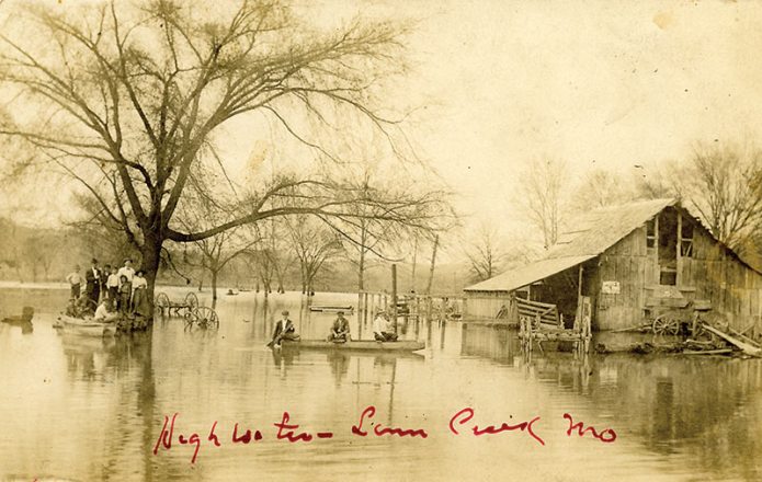
High Water Linn Creek Mo.
Real Photo Postcard by J. W. Farmer, Linn Creek, Mo. probably around 1920. Unsent.

The Osage could play havoc with your plans. Flooding was a regular event in Linn Creek but it didn’t seem to deter people from living there.  Floods were a dramatic and photogenic affair. Even today, a flood brings out the photographers. An obvious question comes to mind: what piece of dry ground was the photographer standing on? Perhaps he was precariously perched on another boat? It’s a great image of a watery world. Hardly a square foot of terra firma is showing!
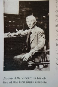
JWVincent-p104


We’ve posted a number of flood scenes of Linn Creek on this blog.  Perhaps several were of a single event, but Linn Creek was hit with rising waters more than once. Despite fairly frequent incursions of the Osage into the town’s streets and homes, the editor of the city newspaper,  The Reveille, railed against building Bagnell Dam.  J.W.)Vincent understood full well that occasional spring rises were better for the community than permanent inundation of their homes and the most productive land of the river bottoms.


This photo (of a photo) of Joshua Williams (J.W.) Vincent is from page 104 in Damming the Osage. The caption reads:

Before coming to Missouri in 1866, J. W. Vincent’s father, J. S., had worked for Horace Greeley, fought in the Mexican War, been wounded twice by Indians, dug for gold in California, and married an Irish girl in Milwaukee. An 1889 county history classified the newspaper he founded as a “spicy journal in the interests of the Republican Party.” The son (J. W. ) bought the Reveille from his father in 1880 and edited it until his death in 1933.
Mar 132016
 

sc424

Real photo postcard. No publisher.

“Dr. Moore L. C. Mo.” is written in red ink. L.C. is Linn Creek Unsent. Penciled on back, “Linn Creek, Mo.” There appear to be some political advertisements pasted in the window. Shows a horse-drawn carriage, sans horses, and a farm wagon hitched to two mules.

Someone really wanted others to know that this scene was in Linn Creek. It says so on the back and twice on the front.  Linn Creek, the seat of Camden County, in spite of being subject to periodic inundation was a thriving little burg before Bagnell Dam. Linn Creek and Tuscumbia were the last towns to have regular steamboat service on the Osage.

Does someone know who Dr. Moore was?


Mar 092016
 

sc417

Real photo postcard published by Jas. Bruin Linn Creek, Mo. This card was never mailed but has a penciled message on the back from Georgia Heaton to Merton Heaton: “This is your little Fluzzy in the hack for a ride. The mules & hack belong to J Bruin the photographer. The one on the left mule yst (sic – used) to be our’s but we sold it to Bruin quite a while. This is by the yard gate.”

Mar 042016
 

sc416The wild scenery at Ha Ha Tonka was appreciated by our ancestors. The walls of the collapsed cavern defied development so they look pretty much today like they did a hundred years ago. The story is (and it’s on most websites about Ha Ha Tonka) that a ring of counterfeiters operated out of this region in the 1830s. We don’t know if they used the cave or not but the name has been affixed to this cave, which is currently off limits at Ha Ha Tonka State Park.

A Chicago Sunday Tribune, April 22, 1956, article about Ha Ha Tonka, “Rainbow Trout Brought a Castle to the Ozark Hills,” describes a driving getaway for Chicago readers at the then-relatively-new Lake of the Ozarks. About Counterfeiters’ Cave, writer Marge Lyon gives a few more details: “There a band of men had turned out excellent half dollars, quarters, and dimes until tracked down by one Augustus Jones, deputy sheriff, in 1834.”

In 1956, it cost a dollar to drive to the ruins and “see stones put together as neatly as books in a case, age-old wonders of nature that have remained unchanged despite dams, castles, hard roads, and all other human innovations that have been brought to this area.”

This is a real photo postcard, by Jas. Bruin, Linn Creek, Mo., postmarked Linn Creek, 1910. It was mailed to Georgia Heaton, Joplin, MO. The penciled writing on the correspondence side of the card is too light to read.

BTW – before the name Ha Ha Tonka, this area was called Gunter Spring, for John Gunter, an earlier landowner from Alabama. More on that later!

Feb 272013
 

HaHaTonka Lake

2 Real Photo postcards by Strathman Photo

Both postcards have been sent, postmarked Linn Creek, but the dates are obscure – probably 1930s.

The exact origin of the low dam that created Ha Ha Tonka Lake is not clear. It’s possible that Colonel R. G. Scott, railroad promoter and real estate hustler, built it.  He came from Iowa about 1890 and  with a friend bought or optioned what was then known as Gunter Spring with a large parcel of land. In 1904, Scott sold the land and spring – now fancifully renamed Ha Ha Tonka with a suitable Indian legend to fit the name – to businessman Robert McClure Snyder of Kansas City.

HaHaTonka Lake Dam

The destruction of this little lake by the construction of Bagnell Dam caused a five year series of lawsuits and appeals. We devoted a significant part of the book (pages 92-97) to the lawsuit and subsequent appeals.

The lawsuit pitted well-to-do people with big egos against a well-to-do corporation with an equally big ego.  The first round began in 1930 when UE filed an exception to the award of $902/acre to the Snyder family for the acreage included with the trout lake. The Snyders sued and the lines were drawn.  The plaintiffs claimed the new lake had degraded their estate more than a million dollars.  High dollar lawyers and a high profile tale brought journalists to cover the lawsuit over ‘scenic beauty versus progress’. Witnesses during the ten-week trial included Gutzon Borglum, sculptor of Mount Rushmore, and W. H. Wurepel, who painted the mural of Ha Ha Tonka in the Missouri State Capitol. In 1932, the jury awarded the Snyder family $350,000.

Naturally UE appealed. Round Two began in 1935. A new verdict awarding $200,000 to the Snyders caused them to appeal, but Judge Otis denied the motion for a third trial in 1936 allowing the $200,000 judgment to stand.

Today the lake laps up against the old mill dam, but the trout dam is under water.


Continue reading »

Dec 052012
 

Real photo postcard, probably 1940s

Lovers Leap was a cliff near Linn Creek, about which J. W. Vincent, editor of the local paper, penned a fanciful tale of a suicidal India maiden.  Virtually every declivity more than 25 feet high in the Mississippi River valley had a similar legend attached to it. When Lake of the Ozarks filled in 1931, the name stayed but the jump got shorter and the landing in water became more survivable. The little creature poised on the rocks in disregard of its safety appears to be some species of dog.


Continue reading »

Oct 242012
 

Real photo postcard, circa 1910

Handwritten’ labels’ on the card beside each fish identify  three blue catfish and two American eels, the largest of which is 27 pounds. At the end of the card is written: “These are fish from the Osage River. Look kinda small here but were larger.”

Today, only eel of course are found in the 85-plus miles of free flowing river below Bagnell Dam. Lock and Dam #1 probably blocks most of their upriver journey, except in high water.


Continue reading »

Oct 172012
 

Real photo postcard, 1915-1925

This came with the identified Lock & Dam #1 photo. It looks like an excursion boat and is named the S. Katherine. Don’t see any smokestacks but it’s also got staple holes, similar to the Lock & Dam #1 postcard. A Google search didn’t find a “Katherine” vessel known to operate on the Osage.


Continue reading »

Aug 262012
 

20120825-214727.jpg

This summer’s drought has drastically lowered water levels on major waterways throughout the Midwest. The Corps of Engineers first major water control project on the Osage – built around the turn of the last century to facilitate steamboat travel – Lock and Dam #1 was if anything an impediment to river commerce. This morning the crumbling hulk lay exposed to sun and camera…. A reminder that water resource projects have a finite usefulness and then become relics and dangerous ruins.

Jul 202012
 

Lock and Dam No. 1

Real photo postcard, 1910-1920.

Businessmen along the Osage River agitated for generations for engineering improvements that would facilitate steamboat traffic on the river. Finally in the late 1800s, politicians bullied the Army Corps of Engineers into building a disastrous lock and dam about nine miles from the junction of the Osage with the Missouri River. Construction costs ran hugely over budget and it failed miserably to provide the projected economic benefits. Fifty years later, the Army Corps of Engineers continued the tradition of intervening in the hydrology of the Osage River with projects that ran over budget and failed to provide promised benefits. Lock & Dam #1 cost somewhere around $750,000 (we think). The six recent interventions by the Corps cost hundreds of millions.

Continue reading »